Scheme Overview
The Scheme comprises the construction, operation and maintenance, and decommissioning of a ground-mounted solar photovoltaic (PV) generating station and associated development, including:
A BESS;
A number of project substations (both 132kv and 400kv); and
A new National Grid substation operated by National Grid Electricity Transmission plc.
The Scheme also involves grid connection infrastructure including works to the existing 400kV overhead line and associated pylon(s), for example, the relocation or moving or the existing pylon(s), new pylons, temporary replacement pylon(s) and restringing of the overhead line. Underground electricity cabling will run between the Solar PV sites within the Cable Route Corridor (CRC) to connect to the BESS and the National Grid substation.
The operational phase of the Scheme is expected to be 60 years. At the end of this period, a decommissioning plan will be enacted. This plan will require the removal of the solar PV panels, substation(s) and the BESS, and the restoration of the Site to its original use. The new National Grid Substation will be retained as it will form part of the transmissions network.
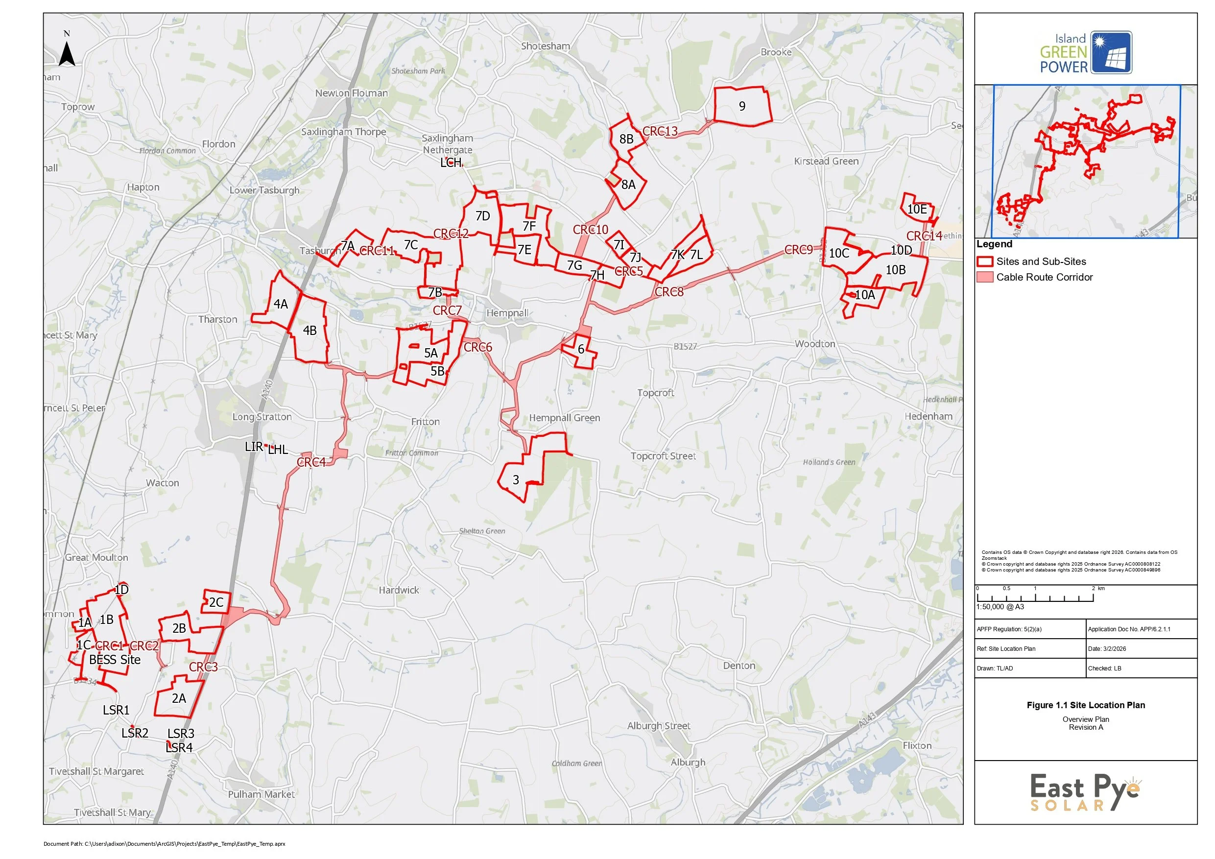
East Pye Solar (the Scheme) is a proposed utility-scale solar park and battery energy storage system (BESS) project to be constructed in South Norfolk. If approved, the Scheme has the potential to provide up to 500MW of renewable energy.
The map on this webpage shows the extent of land required for the construction, operation, maintenance and decommissioning of the Scheme.
The Scheme is located on land south of Norwich and north of Harleston, and will consist of the following sites:
Site 1 (sub-sites 1A, 1B): South-west of Great Moulton;
Site 2 (sub-sites 2A, 2B, 2C): North-west of Pulham Market and South-east of Great Moulton;
Site 3: South of Hempnall;
Site 4 (sub-sites 4A, 4B): North of Long Stratton and South of Tasburgh;
Site 5 (sub-sites 5A, 5B): South-west of Hempnall;
Site 6: South-west of Hempnall and North of Silver Green (no solar infrastructure will be hosted on Site 6, which has been retained for habitat management)
Site 7 (subsites 7A – 7L): Hempnall is located South-west, Tasburgh to the West, Saxlingham Nethergate to the North and Woodton to the South-east;
Site 8 (sub-sites 8A, 8B); South-west of Brooke and North-east of Hempnall;
Site 9: South of Brooke; and
Site 10 (sub-sites 10A – 10E): North-east of Woodton and South-west of Seething.
The BESS site is proposed to be located on land to the south of Site 1.
The National Grid Substation is proposed to be located within Sub-Site 1B.
The Scheme also comprises of associated infrastructure such as:
400kV Project Substations located in the BESS Site and Sub-Sites 5A and 7B.
132kV Project Substations located within Sub-Sites 4B, 7F and 10C.
The Cable Route Corridor - the area of land identified for the proposed underground interconnecting cabling between the Sites, Sub-Sites and BESS Site.
Grid Connection Infrastructure - underground and/or overhead lines including new pylons between the National Grid Substation and the Point of Connection, proposed to be located within Sub-Sites 1A-1D.
Highway Works - the area within which localised improvements to sections of the existing highway network will be completed to facilitate access to the Scheme. For example, improvements to deteroriated road edges and temporary traffic management.
In addition to hosting the solar PV panels and supporting infrastructure, these areas will incorporate biodiversity and environmental enhancements and mitigation. This will ensure that the solar PV panels, BESS, the National Grid substation, and other necessary infrastructure for generating and storing electricity, are carefully and sensitively located in their surroundings.
Further information about the components of the Scheme can be found in ES Volume 1, Chapter 4 - The Scheme (available here on the PINS’ document page).
The Site